One of the most intriguing man-made features of Niagara County is the Erie Canal. The waterway crosses the entire county, from Middleport all the way to North Tonawanda. Most of us pass over the canal or drive alongside it without ever really thinking about it that much. In previous years, our thoughts may have drifted more to the canal as we waited for the bridge to come down, or we spied commercial barges plying the waters. However, most people generally don’t think too much about the path of the canal, or if it’s ever changed.
The original Erie Canal was dug from July 4, 1817 to October 26, 1825. Only 40 feet wide and 4 feet deep, this “Ditch Canal” was almost immediately too small for the amount of commerce it carried. Plans to enlarge the canal were raised within a few years of completion. By 1834, an ambitious plan to enlarge the canal to 70 feet wide and 7 feet deep was begun. Due to several work stoppages, it took until 1862 to complete the first enlargement. Additionally, the canal was enlarged a second time into what we know today as the Erie Barge Canal. Begun in 1905 and completed in 1918, the waterway was widened to 123 feet, and deepened to 12 feet.
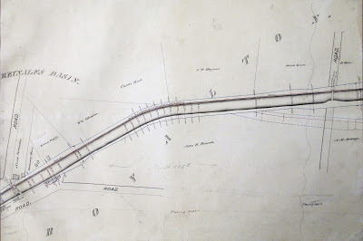 |
| From an 1873 atlas of the Erie Canal, the Enlarged Canal is shown with the path of the Ditch Canal shown in dotted lines. The divergence of the two paths is in the Wruck Road area, east of Reynales Basin. (courtesy Niagara County Historian’s Office) |
Both times the canal was enlarged, the path of the waterway was slightly changed. When it was first dug, the canal followed a path to make it look nearly as natural as possible. In places, it curved with the contour of the land. At the same time due to technological limitations, the canal went around obstacles. With the first enlargement, the canal was straightened, and many of these curves from the Ditch Era were abandoned. Again when the Barge Canal was constructed, a slightly different path was chosen.
So, where were the earlier two incarnations of the Erie Canal? Can any of those areas still be spotted today? In Niagara County, there are several spots where canal remnants can be spotted. They are mostly at either end of the county. Because of the hard work involved with digging the Deep Cut above the locks in Lockport, that section has remained pretty constant. However, some traces of the Ditch Canal and the Enlarged Canal are still waiting to be explored.

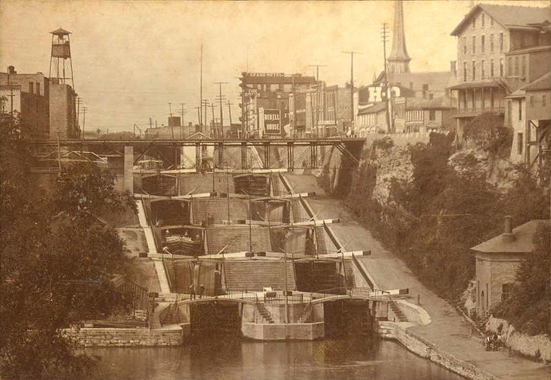
Obviously, the most visible remnant of the Enlarged Canal is the set of five locks alongside the modern locks in downtown Lockport. Constructed in 1841/42, the “Flight of Five” served the west-bound traffic. The southern set, completed in 1849 and serving east-bound boats, was destroyed during the construction of Locks 34 and 35. The construction of these locks in the middle of the nineteenth century resulted in the complete destruction of the original 1825 locks. Since about 1922, the northern set has been relegated to use as a spillway to keep water flowing in the lower section of the canal. Recently, an ongoing effort has been underway to restore these old locks back to working order. If completed, Lockport will boast of the only spot on the canal where the old locks and new locks still work, side by side.
There are a couple places in the Town of Royalton and the Town of Lockport where segments of the Ditch Canal and the Enlarged Canal can be seen. Near the Niagara-Orleans Golf Course at Wruck and Telegraph Roads, a segment of Ditch Canal can be seen if you peer through all the trees in the ramped area going up to where the bridge used to be. There is a ditch on both sides of the road just to the south of the canal. That is the old part of the canal. It’s easier to see on the west side of the road, appearing as a stagnant pond of shallow water. The map here shows the Enlarged Canal in relation to the original canal.
If you’ve ever been to the area of Harrington and North Canal Roads, you’ve probably seen traces of the old canal and never even realized it. Along the farm lane for the Snyder farm is a curving ditch. This is probably the clearest representation we have in Niagara County of the original Erie Canal. The canal navigated a series of “S” turns at the line between the towns of Lockport and Royalton, the reminders of which are very evident at the intersection of these two roads. A ravine along the roadway also was a part of the original canal. Also seen in this area is the ruin of the old North Canal Road before it was rerouted to its present location in April, 1961.
 |
|
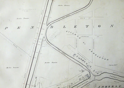
| The paths of the Ditch Canal and the Enlarged Canal are drastically different in Pendleton where the canal meets Tonawanda Creek. (courtesy Niagara County Historians Office) |
The path of the Erie Canal pretty much follows the same path as in 1825 from a point between the Canal Road Bridge and Day Road Bridge, all the way through the City of Lockport, until it gets to Pendleton near the conjunction with Tonawanda Creek. In the hamlet of Pendleton, the Ditch Canal once again meandered, following a looping trail. The enlargement straightened the lines of the waterway and left behind dry oxbows of former canal.
Pendleton was settled by Sylvester Pendleton Clark. He owned the land at the head of the portage between Lockport and Tonawanda Creek before the canal was completed above the locks. In his estimation, that last seven-mile stretch of the Deep Cut would prove to be too difficult to complete. He figured he would be able to control the flow of commerce in both directions. He would make a fortune. Unfortunately, his prediction didn’t pan out and he saw visions of his empire fade with the completion of the canal. When Clark died in 1851, he was buried in the Clark Family Cemetery along the bank of the 1825 Erie Canal. His bones rest alongside the bones of the waterway he had set his fortunes upon never being completed.
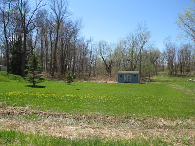 |
| This banks of the Ditch Canal are just visible on the left side of this photo as the small incline. This low-lying area was once the bed of the 1825 canal. (courtesy Craig Bacon) |
The remains of the old canal in Pendleton are still visible, though they are a little harder to find. Situated behind some houses, much of it is difficult to find. However, last spring, fellow historian Ron Cary and I went through the woods to the Clark Cemetery and photographed the sloping banks of Dewitt Clinton’s Grand Erie Canal. Trees and underbrush have grown up in the area further obscuring the outline of the original canal.
Across New York State, there are traces of the older versions of the canal everywhere. Mostly what you can find are the remains of the Enlarged Canal. One of the most often noticed ruin is Lock 52 near Port Byron, which sits alongside the New York State Thruway. Most traces of the 1825 canal have long ago disappeared. Sure, there are still traces throughout the state, but time is erasing those remains. Luckily, in Niagara County, we have several pieces of the Erie Canal that have withstood the ravages of time. Sometimes, you just have to hunt for them. And that can be the best part.
LINK: More photos.